Earthquake! Earthquake! The people of the Khait region of Tajikistan announced! Or more likely given the local Tajik language, Заминларза! Заминларза! This was no normal earthquake it measured 7.4 on the Richter Scale, nor however was it a recent one, this earthquake happened on 10th July 1949 when the region was not Tajikistan but rather part of the Tajik Soviet Socialist Republic, a republic of the Soviet Union. This massive earthquake caused one of the worst landslides in living memory, though little lived through it.
This significant but slightly elusive event has been kept out of the spotlight. The timing and location of this event, soon after the war in an area about which the Soviet Union was very secretive, has meant that it has been very difficult to determine any details about the landslides that were triggered in the earthquake. However, some rather speculative reports have suggested that the impacts were very large – for example this article in Mountain Research and Development reported a huge landslide at a site that it termed Borgulchak Rock. This slide was reported to have travelled 12 km. Some reports, such as the Wikipedia article on this landslide, have suggested a death toll as high as 28,000 people, altho
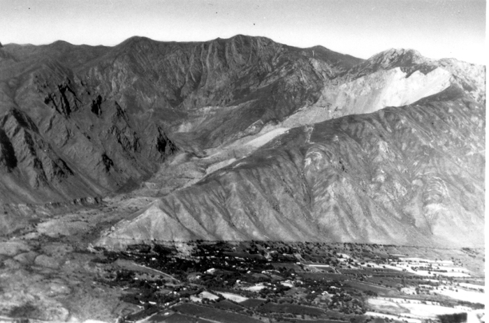
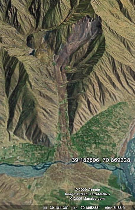
ugh this may well be something of a misinterpretation of the original source as record keeping in the high mountains of Tajikistan in the 1940s was not a priotry of the Soviet Union nor was it perfected.First, they look at the Khait landslide, which is still clearly visible in the landscape, both then (the image on the right) and even on the low resolution Google Earth imagery available for this area (the image on the left):
This significant but slightly elusive event has been kept out of the spotlight. The timing and location of this event, soon after the war in an area about which the Soviet Union was very secretive, has meant that it has been very difficult to determine any details about the landslides that were triggered in the earthquake. However, some rather speculative reports have suggested that the impacts were very large – for example this article in Mountain Research and Development reported a huge landslide at a site that it termed Borgulchak Rock. This slide was reported to have travelled 12 km. Some reports, such as the Wikipedia article on this landslide, have suggested a death toll as high as 28,000 people, altho
An article in the journal Engineering Geology, by Steve Evans seeks to re-examine the landslides triggered by this earthquake. The paper re-evaluates the Khait landslide, and the other large slide that was triggered in the earthquake, providing a rational analysis of the likely impacts of the mass movements and a estimation of possible death tolls.


For the Khait landslide they conclude that the volume was probably rather lower than earlier estimates have suggested. The other landslide considered is a very large and complex flowslide that swept down the Yasman Valley, covering about 20 km. This slide had multiple source areas on the southern side of the valley:

They conclude that this is a rather destructive flow slide with a volume of about 245 million cubic metres. Remarkably it travelled over a slope with an angle of just two degrees!
Evans then consider the fatalities caused by the landslides. By looking at contemporary reports of the population of the Khait area and census data on settlement size and population density they reject earlier estimates of the loss of life. For the Khait landslide itself they conclude that about 800 fatalities is probably a reasonable estimate, it is worthy to note that this very considerably less than earlier estimates. For the Yasman Valley flowslide they estimate about 4,000 fatalities, and they determine that there were probably a further 2,400 deaths. This gives a total fatality count of about 7,200, far lower than previous counts.

No comments:
Post a Comment